One of the main goals of EGSIEM is to establish a hydrological service which provides gravity-based indicators of extreme hydrological events such as floods and droughts. Contrary to other Earth Observation methods which record parameters such as surface reflectance, soil moisture, roughness or temperature; gravity measurements represent variations in the total water storage of the earth system. The EGSIEM hydrological service aims at developing indicators of the actual flood generation potential of a river basin, or of its susceptibility to a drought, thereby contributing to existing flood and drought monitoring and alerting systems. Such systems play a key role in the disaster management domain and in the satellite-based emergency mapping in particular.
Experiences from the Center for Satellite Based Crisis Information (ZKI) show that reliable early warning and alerting systems can improve the time critical tasking of SAR and optical satellites which is of special importance in case of rapidly emerging disasters such as large flood situations. Satellite derived crisis information from data recorded at the flood peak as well as from monitoring of rapidly evolving flood situations can greatly support disaster relief and civil protection measures in flood affected regions.
In the current special issue of the journal Science, an international team of experts led by the German Aerospace Center (DLR) has analysed the historical development of satellite-based emergency mapping. The researchers are presenting global patterns alongside historic and emerging trends in this field.
The full paper can be accessed at: http://science.sciencemag.org/cgi/doi/10.1126/science.aad8728
Abstract: Over the past 15 years, scientists and disaster responders have increasingly used satellite-based Earth observations for global rapid assessment of disaster situations. We review global trends in satellite rapid response and emergency mapping from 2000 to 2014, analyzing more than 1000 incidents in which satellite monitoring was used for assessing major disaster situations. We provide a synthesis of spatial patterns and temporal trends in global satellite emergency mapping efforts and show that satellite-based emergency mapping is most intensively deployed in Asia and Europe and follows well the geographic, physical, and temporal distributions of global natural disasters. We present an outlook on the future use of Earth observation technology for disaster response and mitigation by putting past and current developments into context and perspective.
"Global trends in satellite-based emergency mapping" by Stefan Voigt, Fabio Giulio-Tonolo, Josh Lyons, Jan Kucera, Brenda Jones, Tobias Schneiderhan, Gabriel Platzeck, Kazuya Kaku, Manzul Kumar Hazarika, Lorant Czaran, Suju Li, Wendi Pedersen, Godstime Kadiri James, Catherine Proy, Denis Macharia Muthike, Jerome Bequignon, and Debarati Guha-Sapir published in Science, Volume 353(6296):247-252, July 15, 2016
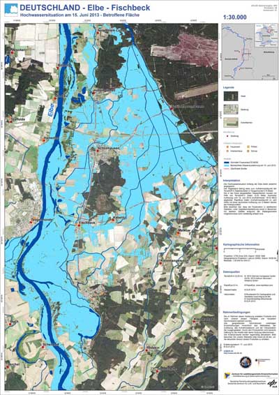
Below, Example of a flood extent map of the River Elbe, Germany 2013