Why do we use GNSS loading?
The Earth’s surface displaces in response to changing surface mass loads. These displacements can be observed with GNSS observations. Thus, GNSS is an independent method for observing mass variations. (The gravity reference frame and the GNSS reference frame are different and this difference will be addressed in the context of this project.) Our validation will not make use of any gravity products but will use coordinate time series from around 2000 GPS stations distributed around the world.
How does it work?
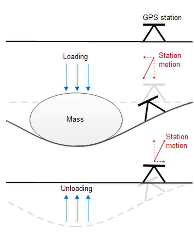
The basic concept is that the stations are affected by mass loading (see figure below). In the no-loading case the surface and, thus, the station remains stable. When mass moves into an area, such as when water enters a valley in the spring as snow in the nearby mountains melts, the surface will be displaced. A nearby GNSS station will experience a motion down and towards the mass. Normally the vertical motion is a factor of two to three times larger than the horizontal motion. As soon as the load vanishes, usually in the fall, the motion is reversed. As we know the elastic properties of the Earth to a sufficient degree, observing this motion we can infer the mass load in the surrounding area. Since the number of stations used for the creation of the reference frame will only be a subset of existing GNSS stations which are globally but sparsely distributed, we will extend (i.e. densify) validation possibilities by using also existing global and regional networks. To ensure the consistency of the different time-series requires then the expertise that is available at ULux.
What is the current status?
At ULux the code for calculating surface displacements from gravity products has already been developed for spherical harmonic coefficients as well as for gridded data as input. The remaining effort will be to streamline the process so that it is semi-automatic, meaning that statistical parameters will be calculated automatically but still requires interpretation and assessment by a human. GNSS loading “unfortunately” observes a different spectrum of the load/mass signal as compared to the satellite gravity-based products. For example, GNSS stations are affected by local phenomena e.g. glacier melting that is too small in spatial scale to be resolved by the satellite. Thus the careful interpretation of any comparison is crucial. The implementation process will finish by the end of the year, and the information will be fed back into the processing chain in order to improve and ultimately provide the best product possible.

