
Why do we use hydrological models?
GRACE allows for the first time to quantify mass variations caused by changes in continental water storage (CWS). To ensure the quality of EGSIEM products, hydrology validation is essential, since these model-based hydrological data could help us to identify outliers, and more importantly increase user’s confidence in our data products.
What are the available hydrological models?
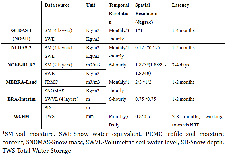
Currently, there are several hydrological models available from different institutions with different spatial and temporal resolutions. The most common components are soil moisture plus snow, often not all compartments are provided, e.g. provided by the Global Land Data Assimilation System (GLDAS), National Centers for Environmental Prediction reanalysis (NCEP-R1, R2), European Center for Medium-Range Weather Forecasts reanalysis interim (ERA-Interim), Modern-Era Retrospective Analysis for Research and Applications land reanalysis (MERRA-Land), together with the regional North American Land Data Assimilation System (NLDAS). Except for the soil moisture plus snow, the WaterGAP Global Hydrological Model (WGHM) provided by GFZ includes groundwater, surface water in rivers, lakes, reservoirs and wetlands.
The details of these hydrological models are listed in the table below.
Since different hydrological models have their own advantages and disadvantages, we will make use of all these above models to validate our EGSIEM gravity products.
How is the progress now?
At Ulux, the code for automatically download the Hydrology models listed in the table, together with calculating surface displacements from these different datasets has been developed except for WGHM, but it will be quickly implemented after we get the latest data from GFZ. Besides, we have also established the programs to combine GNSS loading with position time series calculated from gravity model. Codes for correlation and root mean square (RMS) analysis between hydrological and gravity model, GNSS and gravity model are finished too. The final task will be to assemble them into an online system, and create a user friendly interface so that at the later stage all the validation work could be done semi-automatically by specifying the input and output data.