Until now, monthly GRACE gravity field models have been available with a time delay of about two months, which just allows for the ‘confirmation after occurrence’ and to assess the severity of a hydrological extreme event. The main goal of the EGSIEM NRT service is to reduce this latency significantly to a maximum of five days and to provide daily gravity field models on a regional to global scale. The EGSIEM NRT service will be implemented and operated by the GFZ (German Research Center for Geosciences) and Graz University of Technology (TUG), plausibility tests for the daily solutions will be performed at the University of Luxembourg.To provide the best possible gravity field estimates, two strategies are pursued: TUG focuses on improving global gravity field solutions, whereas GFZ will implement tailored regional representations of the gravity field (check out their recent blog entry for details). Both approaches complement each other, providing global coverage, with increased spatial resolution for regional areas of interest.
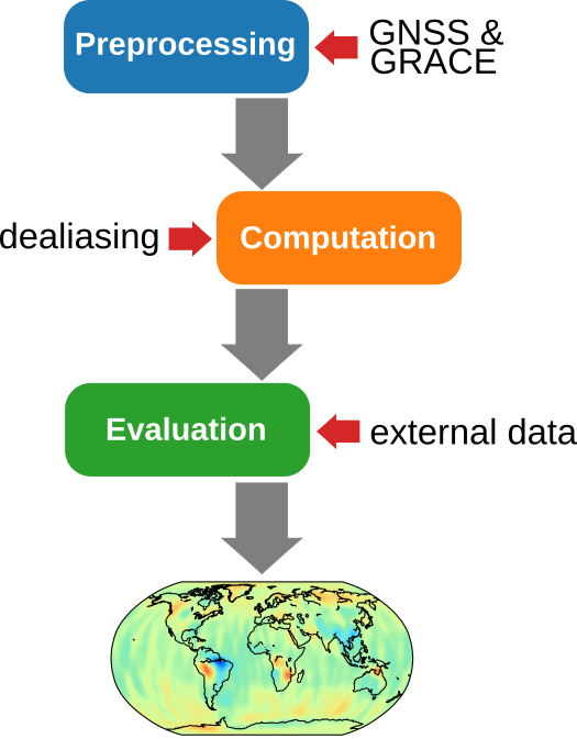
Figure 1: Schematic work flow of the NRT service for a single day. The flow chart shows the individual process steps starting with raw data preprocessing, followed by the computation of the gravity field, until, after external evaluation, the final gravity map is released.
The target latency of the EGSIEM NRT solutions is five days, which is primarily dictated by the availability of the required input products. The preprocessing of GNSS (Global Navigation Satellite System) and GRACE data will be performed on the first day. Then, when dealiasing products for correction of atmospheric and oceanic short-term mass variations become available at approximately day three, the normal equations of the daily solution can be computed. Because the data coverage within one day does not allow for a solution based on GRACE data alone, the gravity maps of the NRT service will employ a prediction – correction principle. We will use information on the temporal behavior of the gravity field to predict the following day, and then improve this prediction with the available GRACE observations. After the correction step, the solution is checked for plausibility with external data, such as GNSS loading, to ensure a reliable estimate.
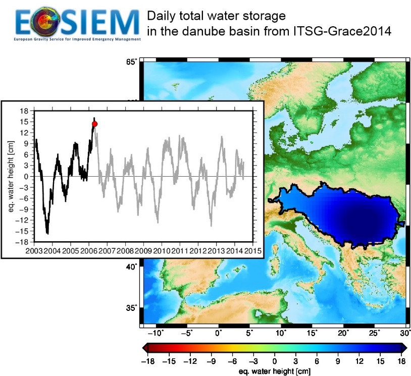
At TUG we are currently in the process of improving and adapting our processing strategies which is the first step towards the operational phase during the last year of the project. To give you an idea of what the NRT gravity products will look like, the figures on this page show a snapshot of the gravity field during the Danube floods in 2006 taken from TUGs post-processing solution.
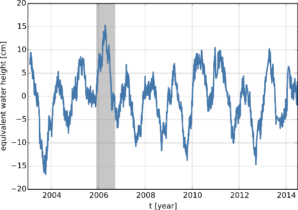
Figure 2: Daily variations of the gravity field in the Danube basin in equivalent water height. The extreme flood event in 2006 is highlighted by the gray rectangle. Similar time series will be used to derive gravity based flood and drought indicators.
Daily Gravity Field Solution Teaser
For those of you who can’t wait to get your hands on the near real-time daily gravity field solutions: TUG provides a continuous time series of gravity field snapshots from February 2003 to June 2014 at itsg.tugraz.at. To get a visual overview you can check out the videos on the EGSIEM website www.egsiem.eu