
Since the establishment of DLR-ZKI (Center for Satellite-Based Crisis Information), the development of EO-based methodologies for the rapid mapping of flood situations has been of major concern. This is can be especially contributed to the fact that inundations constitute the majority of all ZKI activations as well as activations of the International Charter ‘Space and Major Disasters’. These requirements have led to the development of dedicated SAR-based flood mapping tools which have been utilized within numerous rapid mapping activities of flood situations since 2008. The core of these tools is an automatic tile-based thresholding approach (Martinis et al. 2009) which allows separating inundated areas from land-areas without any user interaction. Since 2012, the SAR-based flood detection algorithm has been substantially extended and refined in robustness and transferability to guarantee high classification accuracy under different environmental conditions and sensor configurations allowing its implementation in automatic SAR-based processing chains (Martinis et al. 2014).
The TerraSAR-X Flood Service is a fully-automated processing chain geared towards near real-time pixel-based flood detection based on TerraSAR-X data. Since a manual user-based classification refinement is omitted, a major concern in the design and implementation of the fully-automated processing chain was to reach a high level of robustness and classification accuracy irrespective of differing environmental factors (e.g. land cover, topography) or satellite acquisition characteristics (e.g. incidence angle, spatial resolution). The processing chain, which is composed of SAR data pre-processing, computation and adaption of global auxiliary data, unsupervised initialization of the classification as well as fuzzy logic-based post-classification refinement, is automatically triggered after satellite data delivery. The thematic results are directly ingested into web mapping applications (fig. 1) to visualize and intersect the derived flood information with a number of other relevant geoinformation layers.
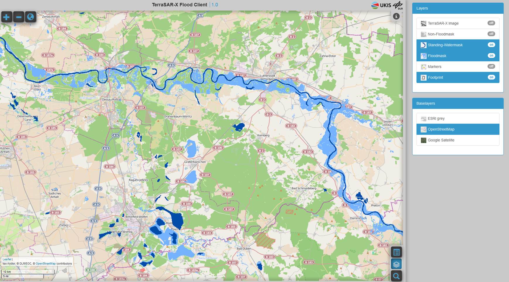
Figure 1: Web client of the TerraSAR-X Flood Service
The processing chain has recently been adapted to the new European Space Agency’s C-band SAR mission Sentinel-1. The thematic processor has further been enhanced through the integration of the “Height above nearest drainage” (HAND) index (Rennó et al. 2008) which helps to reduce water look-alikes depending on the hydrologic-topographic setting. The HAND index has been calculated globally based on elevation and drainage direction information provided by the Hydrosheds mapping product.
In contrast to the current TerraSAR-X based thematic service, Sentinel-1 enables a systematic disaster monitoring with high spatial and temporal resolutions. This is a major advantage since the time-consuming step of tasking new satellite data can be omitted. In order to allow an immediate processing, data streams from the Collaborative Ground Segment and Sentinel Data Hub can directly be ingested into the processing chain. In an experimental study, a near real-time (NRT) data access to Sentinel-1 data through DFD’s ground station in Neustrelitz is currently being implemented to allow an even faster data access for scenes acquired over European territories.
References:
Martinis, S., Twele, A., Kersten, J., 2014: A fully automated TerraSAR-X based flood service. ISPRS Journal of Photogrammetry and Remote Sensing, Volume 104, June 2015, Pages 203–212.
Martinis, S., Twele, A., Voigt, S., 2009: Towards operational near real-time flood detection using a split-based automatic thresholding procedure on high resolution TerraSAR-X data. Natural Hazards and Earth System Sciences (NHESS), 9, 303-314.
Rennó, C. D., Nobre, A. D., Cuartas, L. A., Soares, J. V., Hodnett, M. G., Tomasella, J. & Waterloo, M. J., 2008: HAND, a new terrain descriptor using SRTM-DEM: Mapping terrafirme rainforest environments in Amazonia. Remote Sensing of Environment, 112 (9), 3469-3481.