
On the relative weighting between GPS and KBR measurements in GRACE data processing
The GRACE GPS data provides, besides absolute satellite positions, information on the gravity field that is lacking in the K-band ranging measurements (KBR; microwave satellite-to-satellite ranging). The sectorial coefficients, on the diagonal of the triangle of spherical harmonics coefficients, are badly sensed by the KBR instrument due to the polar orbit. The 3-D information, although not as accurate, provided by the GPS data complements the precise North-South information provided by the KBR measurements. The coefficients that are modified by the contribution of the GPS data are displayed in the plot below. They are mostly in the low degrees of the gravity field, corresponding to the longest spatial wavelengths, and along the diagonal (i.e. sectorial coefficients). The amplitudes of the coefficients are expressed in cm of equivalent water height.
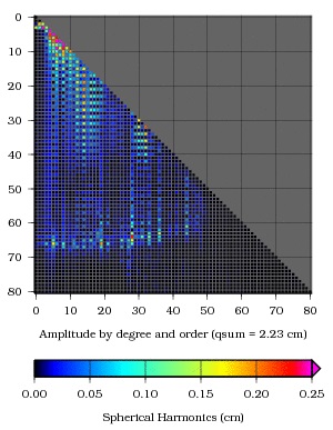
However, the GPS data must not be over-weighted and the maximum spherical degree to which it participates in the global solution should be carefully selected. As an example, the figures below show a situation in which the weight of the GPS data has been arbitrarily increased by a factor of 10. Two cases are tested: in the first, the GPS data participates only to the determination of degrees 2-40 of the gravity field, whereas in the second it participates in the determination of degrees 2-80.
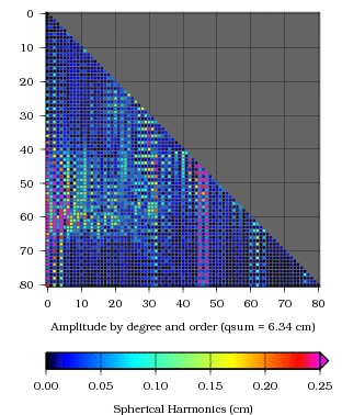
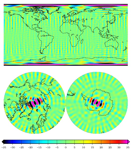
Differences between a solution in which the GPS data is merged with the KBR data up to degree 40 with a solution in which it is merged up to degree 80. To the left: in terms of spherical harmonic coefficients. To the right: in terms of geographical distribution (unit: cm of equivalent water height)
It is clear from the pictures that the GPS data above degree 40 has introduced artefacts in the solution, mostly in two areas: in the resonance bands between orders 45 and 47, and 60 and 65, where the information coming from the GPS data is strong, but where this information is heavily correlated between coefficients of the same parity; and also in the area of high degrees / low orders which produces the spurious signatures over the poles.
The balance between the GPS and the KBR data is thus not just a matter of weighting, but to some degree it is also a matter of order…